Latest Update 4:54 p.m., Oct. 4, 2019:
Press Release: Significant Flooding Not Expected Saturday
City engineers expect Lake Monona to remain near the 100-year flood stage through Sunday, and dry weather early next week will be helpful and welcome. However, some rain is expected on Saturday.
The National Weather Service expects about less than a half of an inch of rain to arrive on Saturday, Oct. 5. The heaviest rain is expected late afternoon to early evening with lighter rain before and after. The storms will be progressive. Moderate rain is possible at times. If the forecast holds, this rain is not expected to cause significant flooding, but residents and visitors should monitor the weather for changing conditions. If conditions change, the City is prepared to respond. Even a prolonged moderate rain could cause some minor flooding given how high the lake levels are.
Current Lake levels: Oct. 4, 2019
- Lake Mendota
- Current elevation: 851.97 feet
- Up 0.15 feet from Oct. 3, 2019
- 0.83 feet below the 100-year flood (which is 852.80 feet)
- 0.77 feet below historic high (Historic High is 852.74, June 6, 2000)
- Lake Monona
- Current elevation: 847.65 feet
- Unchanged from Oct. 3, 2019
- 0.05 feet below 100-year flood (which is 847.7 feet)
- 0.88 feet below the historic high (which is 848.53 feet, Sept. 6, 2018)
Sandbag locations open, available:
- Engineering Service Building, 1600 Emil St.
- Olbrich Park Secondary Boat Launch Parking Lot, 3402 Atwood Ave.
- Olin Park Parking Lot, 1156 Olin-Turville Court
- Spring Harbor Park Parking Lot, 5417 Lake Mendota Dr.
- Tenney Park Beach Parking Lot, 1254 Sherman Ave.
- Thut Park, 2630 Nana Way
- Warner Park Beach Parking Lot, 1101 Woodward Dr.
Visit the City’s flooding website for sandbag information and how to fill and place sandbags properly .
It takes a team
During the past week, City agencies have put in a lot of hours to keep the community safe and informed. City managers monitored the changing weather, the Madison Police Department blocked flooded intersections and crews from the Traffic Engineering Division put up barricades for road closures. The Streets Division supplied other departments with needed materials. The Engineering Division and Parks Division protected property and kept flooded paths open. Information Technology coordinated digital outreach to keep the public informed. While we anticipate the next rain moving in on Saturday, the coordination between agencies has been vital and smooth, and will continue to be until drier weather arrives next week.
Other reminders
- Don’t drive through standing water.
- Report flooding to Engineering Operations: 608-266-4430
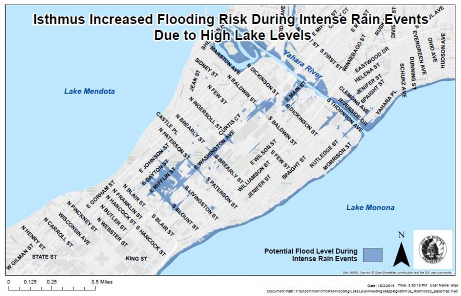
- When intense rain is predicted, avoid parking in low lying areas of the isthmus and the near east side.
- Avoid parking in other areas known to have flooded in the past.
- Sign up for flooding text alerts for closures.
- Sign up for weekly flooding updates
- Know where the nearest sandbag fill locations are.
- Visit the City’s flooding website for other resources.
Update 6:55 p.m., Oct. 3, 2019:
Press Release: Next Flood Threat: Saturday
City engineers expect Lake Monona to crest today around the 100-year flood elevation following the rain that came Tuesday night into Wednesday morning. Additional rain, forecast for Saturday, is likely to bring Lake Monona water levels at or slightly above the 100-year flood elevation. A significant lowering of Lake Monona water level prior to Saturday’s rain is not likely.
Urban flash flooding is not a concern through Friday evening. However, the forecast will be monitored for Saturday, Oct. 5. The National Weather Service expects 0.25-0.75 inches of rain in Madison on Saturday, Oct. 5. Even sustained moderate rains in the East isthmus could cause flash flooding at the current lake and river levels.
Current Lake levels: Oct. 3, 2019
- Lake Mendota
- Current elevation: 851.82 feet
- Up 0.37 feet from Oct. 2, 2019, up 0.84 feet since Oct. 1, 2019
- 0.98 feet below the 100-year flood (which is 852.80 feet)
- 0.92 feet below historic high (Historic High is 852.74, June 6, 2000)
- Lake Monona
- Current elevation: 847.65 feet
- Up 0.15 feet from Oct. 2, 2019, up 0.67 since Oct. 1, 2019
- 0.05 feet below 100-year flood (which is 847.7 feet)
- 0.88 feet below the historic high (which is 848.53 feet, Sept. 6, 2018)
Before Saturday
Residents or businesses located in the low-lying areas of the east isthmus and near east side should prepare their property for potential flash flooding. One option would be to fill sandbags at one of the City’s sandbag locations:
- Engineering Service Building, 1600 Emil St.
- Olbrich Park Secondary Boat Launch Parking Lot, 3402 Atwood Ave.
- Olin Park Parking Lot, 1156 Olin-Turville Court
- Spring Harbor Park Parking Lot, 5417 Lake Mendota Dr.
- Tenney Park Beach Parking Lot, 1254 Sherman Ave.
- Thut Park, 2630 Nana Way
- Warner Park Beach Parking Lot, 1101 Woodward Dr.
Residents should bring their own shovel to load sand bags. Visit the City’s flooding website for sandbag information and how to fill and place sandbags properly .
Barricades remain at most low-lying intersections most prone to urban flash flooding again in case they are needed on Saturday. However, all roads and major paths are currently open.
Other reminders
- Don’t drive through standing water.
- When intense rain is predicted, avoid parking in low lying areas of the isthmus and the near east side.
- Avoid parking in other areas known to have flooded in the past.
- Sign up for flooding text alerts for closures.
- Sign up for weekly flooding updates
- Know where the nearest sandbag fill locations are.
- Visit the City’s flooding website for other resources.